A working page that collects what we have on file about the land and the building. It starts with the boundary survey. Everything after it is approximate. Refer to the recorded survey.
1 · Boundary survey
The signed boundary survey
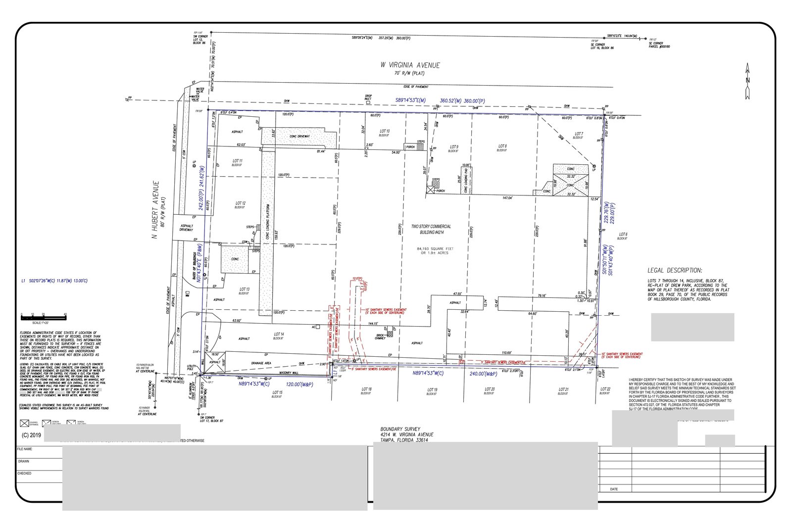
This is the actual boundary survey we have on file for 4214 W Virginia Ave. It was signed and sealed by a Florida surveyor in December 2019.
Dated 2019 and certified only to the parties named on the sheet. Nothing on it has been re-verified by us, and we have not confirmed that its measurements, markers, easements or improvements are still accurate today. It pre-dates current improvements on the site. Use it as the starting record, not as a current survey.
Boundary survey · field date 12/02/2019 · signed 2019.12.041 sheet
Rendered at 150 dpi (5400 × 3600 px). The sheet is rotated 90° so it reads left to right. Drag to pan, scroll or pinch to zoom, double-click to zoom in. Survey available on request.
Title
Boundary Survey, 4214 W. Virginia Avenue, Tampa, Florida 33614
Surveyor
A Florida licensed surveyor and mapper. Electronically signed and sealed under Section 472.027, Florida Statutes and Chapter 5J-17, F.A.C.
Field survey date
12/02/2019
Signed
2019.12.04, 20:54:11 −05′00′ (digital signature stamp on the sheet)
Legal description
Lots 7 through 14, inclusive, Block 87, Re-Plat of Drew Park, according to the map or plat thereof as recorded in Plat Book 29, Page 70, of the Public Records of Hillsborough County, Florida.
Area
84,193 square feet or 1.9± acres (as printed)
Boundary as drawn
Along W Virginia Ave (north): 360.52′ measured, 360.00′ plat. West, along N Hubert Ave: 241.62′ measured, 242.00′ plat. East: 229.76′ measured, 229.00′ plat. South: 240.00′ and 120.00′, measured and plat, with a short jog between them. Scale 1″ = 20′. W Virginia Ave is labeled 70′ R/W (plat). The N Hubert Ave right-of-way width is UNKNOWN (the label is faint and was not read with confidence).
Improvements shown
“Two story commercial building #4214”, concrete loading platform, concrete driveway, asphalt, a drainage area, a masonry wall and fences, and utility features.
Easements shown
Sanitary sewer easements drawn in red: 5′ and 10′ (5′ each side of centerline).
Survey type note
“Unless stated otherwise this survey is an as-built survey showing visible improvements in relation to survey markers found.” Underground foundations and utilities were not located.
Not readable
UNKNOWN — the N Hubert Ave right-of-way width, and any bearing or length not listed above. Refer to the recorded survey.
Facts above were read from the rendered sheet. We have not re-verified anything on the survey, and it is certified only to the parties named on the sheet. If a figure matters, refer to the recorded survey.
2 · Site map · layers
The site and its streets, with layers
One map. Turn the layers on and off to see the parcel, the surveyed boundary, the unit floor plan and the Unit 9 items on top of the aerial photo. Drag to move, scroll or use the buttons to zoom.
Approximate. Refer to the recorded survey.Alignment is by eye
Approximate. The aerial has no survey markers, so every layer is placed by eye and is not a surveyed position. The survey boundary layer is drawn from the dimensions printed on the signed 2019 survey in section 1 and pinned to the same spot as the parcel outline.
Street names come from the base map and were checked against the address search for each side of the parcel: West Virginia Avenue to the north, North Hubert Avenue to the west, West Kentucky Avenue to the south. The unit shapes, colors and Unit 9 items come from the current first-floor unit plan page, and the X box is placed at plan point x2400, y430. Not for construction or permitting. Building plans (HVAC, data and roof) are coming soon.
Marker
Layer
Plan pixel (x, y)
The plan source
Our updated unit plan
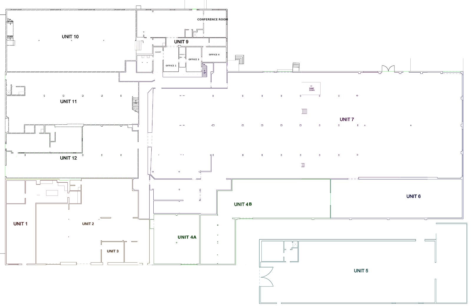
This is the current first-floor unit plan, the same one on the Floor Plan page. The units and numbers on the map above come from it.
Current unit numberingUpdated first-floor unit plan.
The Tampa Bay Rays are building a new ballpark on the Hillsborough College Dale Mabry campus. Our building sits just west of that campus, in Drew Park. This map zooms out to show our site, the campus, the ballpark spot, the other land in the deal, Raymond James Stadium and Tampa International Airport.
ApproximateResearch as of Oct 1, 2026
The ballpark parcel is not a surveyed line. The deal only publishes it as a picture (Exhibit F-1 of the Development and Funding Agreement), with no coordinates. The red box is a 21.5-acre square pinned to the southeast corner of the campus, which is where the sources put it. Real shape and position will differ. The county land parcels (blue, purple, orange, teal, grey) are drawn from county records, but which parcel plays which role in the deal is our inference. The mixed-use area is the campus minus the ballpark, as the agreement defines it, and the district names are placed only roughly.
About the airport. The airport next to this site is Tampa International (KTPA), and that is the one outlined. We found no private airfield nearby. Peter O. Knight (about 9.6 km southeast) and Tampa Executive (about 17 km east-northeast) are public general-aviation fields owned by the same county aviation authority, and they are too far to be on this map. Our block is about 0.55 km from the airport boundary, and the east end of runway 10/28 is about 1.06 km due south.
Drag to move, scroll or pinch to zoom. Click any place (the airport, the ballpark, the stadiums, the college land) to read about it. More labels appear as you zoom in.
Base photo: Esri World Imagery. Street names: Esri. Airport, Raymond James and Steinbrenner outlines: OpenStreetMap. Parcel outlines: Hillsborough County Property Appraiser (parcel layer dated Sept 23, 2026). Everything else is placed by hand from the sources listed below. Not for survey, legal or lending use.
What is where
Three kinds of places in the deal
1 · The stadium
~21.5 acresBallpark on the southeast corner of the campus, at N Dale Mabry Hwy and W Tampa Bay Blvd. After it is built, the college hands this land to Hillsborough County, which will own the ballpark.
Address reported as 4001 W Tampa Bay Blvd (not checked against county records).
2 · Other lots
State, county, collegeAbout 22 acres of state land in 3 separate pieces was approved for the college on Feb 24, 2026. The county owns 24.77 acres at the northeast corner. The college keeps a College District on the west and southwest side along N Lois Ave, marked “HC (Not Included)” in the agreement.
3 · Mixed-use buildout
The rest of the campusThe agreement defines it as the whole campus (about 115 acres) minus the ballpark parcel. Named districts: Champions Quarter (ballpark), Innovation Edge (college), The Canopy (northwest, along MLK and Lois) and The Row (the connecting street).
Campus size is reported as 108, 113, 115, 120 and 130 acres in different sources. The county parcels that make up the campus add up to about 125 acres, but that includes state land. One news story put Champions Quarter on the southwest corner. The others, and the agreement’s exhibits, say southeast, so the map uses southeast.
Phases · now, next, later
What exists, what is approved, what is scheduled
When
What
Now
The aerial photo shows the campus as it exists today: college buildings and parking, with Raymond James Stadium and Steinbrenner Field across and beside it. We found no source confirming that a groundbreaking has happened. As of Sept 24, 2026, site work was described as “in the coming weeks.”
Approved
City Council approved the deal 4–3 on Aug 27, 2026, and the County Commission approved it 5–2 on Aug 28, 2026.
Sept 2026
Targeted groundbreaking and site preparation. Not confirmed.
Oct 31, 2026
Deadline for the ballpark operating agreement. City and county interlocal agreements are due Dec 16–17, 2026.
Dec 2026
Demolition of five college buildings in the ballpark footprint, after the community benefits agreement and bond validation are done.
Mar 2027
Foundation and bowl work begins. A community development district must be set up by June 30, 2027, or the Rays can terminate.
2029
Opening Day 2029. The agreement sets substantial completion at March 31, 2029. The builder documents say Dec 31, 2028 for substantial completion and March 1, 2029 for final completion.
Mixed-use buildout, three phases
These phases are a county planning assumption from the AECOM study (April 10, 2026). They are conceptual. No source shows where each phase would sit, so we have not drawn phases on the map.
Phase 1 2029–2038
1,200 apartments 280,000 sq ft office 150,000 sq ft retail 625 hotel rooms
Phase 2 2039–2048
2,150 apartments 205,000 sq ft office 60,000 sq ft retail 225 hotel rooms
Phase 3 2049–2058
1,425 apartments 205,000 sq ft office 90,000 sq ft retail
Those add up to about 4,775 apartments, 690,000 sq ft of office, 300,000 sq ft of retail and 850 hotel rooms (the report’s own text says 4,750 and 860 elsewhere). Building heights are limited because the site is close to the airport runways.
How far from our block
Distances from 4214 W Virginia Ave
Nearest campus land
About 50 m east (the state parcel at the west edge of the campus, along N Lois Ave).
Ballpark zone
About 0.8 km southeast to the middle of the zone, about 1.0 km to its corner. Approximate.
College District
About 450 m south.
Steinbrenner Field
About 0.7 km east.
Raymond James Stadium
About 1.0 to 1.1 km east-southeast.
Airport boundary
About 0.55 km west-southwest. East end of runway 10/28 about 1.06 km south.
Drew Park CRA
Our block is inside the Drew Park community redevelopment area, which is one of the funding sources for the project. Distances are straight-line.
Which parcel is ours
The county’s record for 4214 W Virginia Ave is the 1.92-acre parcel (Block 87, Lots 7–14), which matches the survey in section 1. The next parcel east, at 4220 N Lois Ave, is a separate owner.